Coverage Report
Generate a custom tailored report breaking down cell coverage and signal strength from all major carriers based on your locations of interest.
14-day free trial. No credit card required.

Key Features
Everything you need to integrate cellular coverage data into your applications.
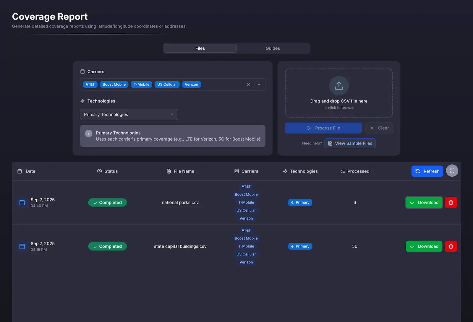
Simple, Intuitive Interface
Upload your list of addresses or coordinates using our simple to use interface, and we'll generate a report with the data you need.
Explore Your Data on an Interactive Map
Every location you upload is plotted on a browsable map with carrier signal strength data overlaid right on top. Pan, zoom, and switch networks to see exactly how coverage looks at and around each of your points, no spreadsheet required.
Dive deeper into Coverage Report
Explore the technical details, data coverage, and real-world use cases so your team can plan a confident rollout.
What is the Coverage Report?
The Coverage Report lets you upload a CSV of addresses or coordinates and receive a detailed CSV file with signal strength, coverage percentages, and tower distance. Use it to evaluate large location lists for planning, sales, or provisioning decisions.
The report displays the average signal strength and percentage of coverage in quarter, half, and one mile radii around each location. It will also show the estimated distance, in miles, to the nearest cell tower.
Simply upload your list of addresses or coordinates in a CSV file, and we'll send you a CSV (or Excel) file with the data you need.
Report Format
Each row in the CSV file represents a location you uploaded. The response file contains every carrier & technology combination you requested, with coverage broken down as follows:
| Row | Description |
|---|---|
| Signal | Signal strength in dBm at the location |
| Quarter Mile Signal | Average signal strength in a 1/4 mile radius around the location |
| Half Mile Signal | Average signal strength in a 1/2 mile radius around the location |
| One Mile Signal | Average signal strength in a 1 mile radius around the location |
| Quarter Mile Coverage | Percentage of coverage in a 1/4 mile radius around the location |
| Half Mile Coverage | Percentage of coverage in a 1/2 mile radius around the location |
| One Mile Coverage | Percentage of coverage in a 1 mile radius around the location |
| Tower Distance | Estimated distance to the nearest cell tower in miles |
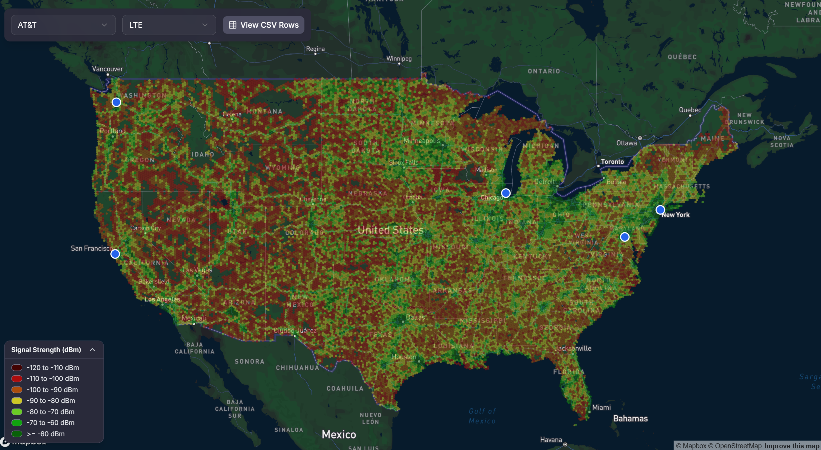
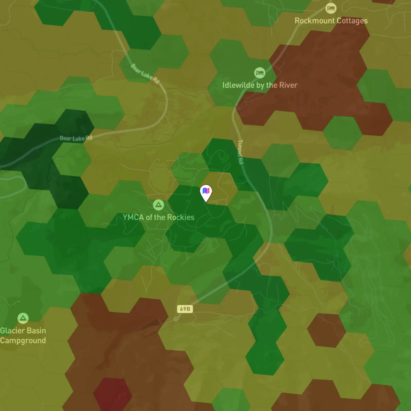
Visualize Your Data on an Interactive Map
Beyond the downloadable report, every location you upload is plotted on a browsable, interactive map with carrier signal strength data overlaid directly on top. Instead of reading through rows of numbers, you can pan and zoom around your locations and instantly see how coverage looks at and around each point.
Switch between carriers and toggle between 4G LTE and 5G to compare networks side by side, with a color-coded signal strength legend ranging from -120 dBm (very weak) to -60 dBm (very strong). Your uploaded locations are marked on the map so you can connect the dots between your data and the surrounding coverage at a glance.
- Browse Your Uploaded Locations: Every point from your file is plotted on a pannable, zoomable map.
- Signal Strength Overlay: See color-coded coverage from -120 dBm to -60 dBm layered around each location.
- Compare Carriers & Technologies: Switch between AT&T, T-Mobile, Verizon, Boost Mobile, and UScellular across 4G LTE and 5G.
- Jump to the Data: View the underlying CSV rows for your locations right alongside the map.
Fast & Easy to Use
Process up to 10,000 locations per file with our easy-to-use dashboard.
- 10,000 Lookups per File: Get signal strength data for up to 10,000 addresses or lat/lon coordinates per file.
- Unlimited Downloads: Re-download your past files as many times as you'd like, free of charge.
- All Major Networks: See coverage and signal strength data for AT&T, T-Mobile, Verizon, Boost Mobile, and UScellular. Regional carriers available upon request.
Pricing
Scale from monthly usage to custom volumes.
- 1,000 locations per month included
- $0.15 per additional location
- Up to 10,000 locations per file
- Unlimited file downloads
- All major networks in the U.S. (AT&T, T-Mobile, Verizon, Boost Mobile, and UScellular)
- Non-commercial license
- 10,000 locations per month included
- $0.06 per additional location
- Up to 10,000 locations per file
- Unlimited file downloads
- All major networks in the U.S. (AT&T, T-Mobile, Verizon, Boost Mobile, and UScellular)
- Non-commercial license
- Up to 10,000 locations per file
- Unlimited file downloads
- All major networks in the U.S. (AT&T, T-Mobile, Verizon, Boost Mobile, and UScellular)
- Additional regional carriers available upon request
- Volume discounts
- Custom pricing for your needs
- Non-commercial & commercial licenses available
Use Cases
Turn large location lists into clear coverage insights.
Unlock Powerful Insights
Each report breaks down network reception in dBm and coverage percentage for AT&T, T-Mobile, Verizon, Boost Mobile, and UScelluar. You'll also see the estimated distance to the nearest cell tower.

Supercharge Your Sales Team
Get coverage insights for prospective customers' addresses. Enable your sales team to speak confidently about coverage quality to prospective customers, and help customers understand the differences between networks at their locations.
Prevent Customer Returns
Avoid returns from slow data speeds or poor reception. Pre-provision your products with the best network at a customer's address to give them an out-of-box great experience.
Why chose CoverageMap.com?
We provide crowdsourced and data-driven maps and APIs of cellular network coverage and performance. Our mission is to help you and your business understand and compare coverage, speed, and signal quality between the carriers.
Where’s the data from?
All of our signal strength data is sourced from the FCC Broadband Data Collection. Our proprietary data processing pipeline handles discrepancies, inconsistencies, or other quality issues with data from the FCC, ensuring you get the most accurate and reliable coverage information possible.
Frequently Asked Questions
What does the free trial include?
The free trial is for 14 days and includes 25 location lookups. The output data can only be used for demo or trial purposes and cannot be used outside of that.
What counts as a location lookup?
Each coordinate or address that is successfully processed by the system counts as one location lookup. Locations that are not successfully looked up, potentially due to formatting errors or other factors, do not count towards your monthly total.
How do I upload locations?
You upload locations by uploading a CSV file with the list of your locations. If you are uploading coordinates, then the CSV file headings will be "latitude" and "longitude" followed by the list of coordinates. If you are uploading addresses, then your CSV file heading will be "addresses" followed by the list of addresses. We provide examples in our documentation.
What format do I get the data in?
Once your locations are processed, you will get the data back in the form of a CSV file and an Excel file. If you are interested, you can also access the signal strength data through our Coverage API or Coverage Tiles.
Can I view my uploaded locations on a map?
Yes. Every report includes an interactive map where the locations you uploaded are plotted alongside carrier signal strength data overlaid on top. You can pan and zoom around your points, switch between carriers, and toggle between 4G LTE and 5G to visually explore coverage at each location.
How do we ensure data accuracy?
We have a custom data processing pipeline to apply corrections to the FCC data. This includes dealing with inaccuracies and discrepancies, and applying our correction algorithm to normalize the data between carriers.
Can I track my usage?
Yes. You can track your usage in real-time from your dashboard and see usage broken down day-by-day.
What countries are supported?
The Coverage Report is only available in the United States.
Ready to get started?
Start your free 14-day trial today. No credit card required. Upload a CSV of locations and get detailed coverage reports.